Civil War and period maps
This site will provide you with high quality prints of historic maps in a variety of stock and sizes. A hugh effort has been taken to make them suitable for wall display. The budget color and black/white prints can be rolled or folded for in the field. This collection will contain maps of the Confederate States Army; by Jed Hotchkiss & S. Howell Brown. The Jefferson County, VW maps were drawn by S.Howell Brown showing owners and property lines. Not forgetting maps by Northerner Robert Knox Sneden taken from his diary showing battlefields with positions of troops, plus others that captured this period on cloth and paper.For information please email varocksplus@hardynet.com SHIPPING $25.00
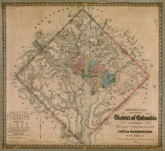 1862 CIVIL WAR MAP OF WASHINGTON D.C. Topographical map of the original District of Columbia and environs showing the fortifications around the city of Washington / by E.G. Arnold C.E.
Note: Shortly after the map was published it was realized that if the map fell into the hands of the Rebel forces it would give them the advantage on an invasion of the Capital. Therefore all maps were collected from shops and persons, plus agents were sent to Colton's in New York to destroy the plates.
Color map on matte archivable paper 36 x 32 inches $85.00
 "MAP OF THE VALLEY" By Jed Hotckiss Typographical Engineer for General Thomas "Stonewall" J. Jackson C.S.A.. This was the map Stonewall asked Jed Hotckiss to make during the civil war. Recognizing Hotchkiss's ability Jackson asked if he would make a map of the valley from Harpers Ferry to Lexington. Jackson didn't live to make use of the map and Hotchkiss had only mapped from the Rockbridge county line to the Jefferson county line. The map shows roads in red, rivers and creeks in blue, mountain passes, property owners and more. High quality printing is available email for price. Any questions please email, click her for close-up view.
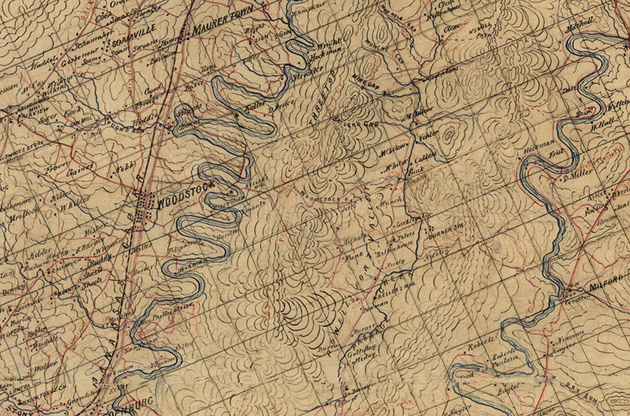
Printed on Enhanced matte paper with archival ink or Glossy (you choice):
Color Map 35x77 $160.00 Email to request high quality art paper printing.
These maps are printed from the original, therefore they're not perfect. Great effort has been taken to make them very suitable for wall display. The black and white prints can be rolled or folded for the field.
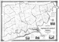
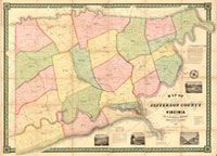 1852 MAP OF JEFFERSON COUNTY VIRGINIA (now West Virginia) W/PROPERTY OWNERS
By: Samuel Howell Brown: S. H. Brown was the county surveyor for Jefferson County. The 2 county maps offered here are called the book marks of his career. The 1852 being his career at the age of 21 years.
Highest quality; printed on heavy archival paper your choice glossy or matte:
Color Map 36x50 $100.00
 Color Map 11x14 card stock matte $7.50
Black & White 36x50 $18.00
These maps are printed from the original, therefore they're not perfect. Great effort has been taken to make them very suitable for wall display. The black and white prints can be rolled or folded for the field.
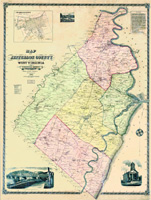 1883 MAP OF JEFFERSON COUNTY WEST VIRGINIA W/PROPERTY OWNERS
By: Samuel Howell Brown: S. H. Brown was the county surveyor for Jefferson County. The 2 county maps offered here are called the book marks of his career. The 1883 ending his career as county surveyor. It has been suggested that the shields in each corner of the 1883 map show his exception of a United country after all Samuel chose to support his state of Virginia during the Civil War.
Highest quality; printed on heavy archival paper your choice glossy or matte:
Color Map 36x48 $100.00
 The maps are printed from the original, therefore they're not perfect. Great effort has been taken to make them very suitable for wall display. The black and white prints can be rolled or folded for the field.
Black & White 36x48 $18.00
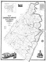
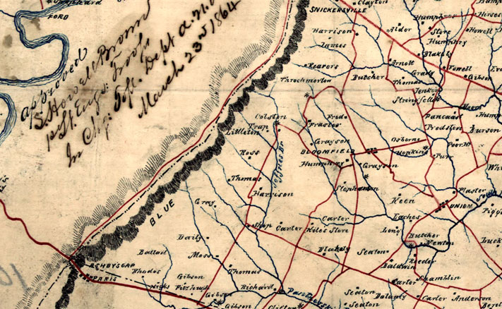
 1864 Civil War MAP SHOWING PARTS OF LOUDOUN & FREDERICK COUNTY, VIRGINIA; BERKELEY & JEFFERSON COUNTY WEST VIRGINIA; and parts of FREDERICK & WASHINGTON COUNTY, MARYLAND W/PROPERTY OWNERS
By: Samuel Howell Brown 1st Lieutenant of Engineer Troops C.S.A.
Highest quality; printed on heavy archival paper your choice glossy or matte:
Color Map 24x21 $65.00 click here for close view
 Budget line; printed on 20 mil paper with archival ink (matte only):
Color Map 24x21 $20.00 The maps are printed from the original, therefore they're not perfect. Great effort has been taken to make them very suitable for wall display. The black and white prints can be rolled or folded for the field.
Black & White 24x21 $13.00
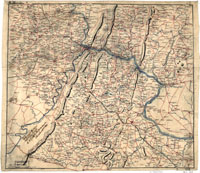
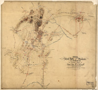
 1864 Civil War MAP OF THE LOWER SHENANDOAH VALLEY; BERKELEY and JEFFERSON COUNTY WEST VIRGINIA; and parts of FREDERICK COUNTY VIRGINIA W/PROPERTY OWNERS. By: Samuel Howell Brown 1st Lieutenant of Engineer Troops C.S.A. Gen. Thomas "Stonewall" Jackson asked Brown to make him a map of the Lower Valley as he asked Jed Hotchkiss to "make me a map of the Valley" which is offered in color only.
Highest quality; printed on heavy archival paper your choice glossy or matte:
Color Map 30x22 $75.00
 Budget line; printed on 20 mil paper with archival ink (matte only):
Color Map 30x22 $30.00 The maps are printed from the original, therefore they're not perfect. Great effort has been taken to make them very suitable for wall display. The black and white prints can be rolled or folded for the field.
Black & White 33x22 $15.00
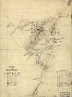 1862 Civil War MAP; BATTLE OF KERNSTOWN Sunday, 23 March, 1862 By. Jed Hotchkiss, Top. Eng. Valley Division.
Highest quality; printed on heavy archival paper your choice glossy or matte:
Color Map 24x18 $55.00 This size is larger than the original map which allows more ease in viewing with the unadded eye.
Color Map 11x15 $7.50 Original size The maps are printed from the original, therefore they're not perfect. Great effort has been taken to make them very suitable for wall display. The black and white prints can be rolled or folded for the field.
 1862 Civil War MAP; BATTLE OF KERNSTOWN with hatch marks click here for close-up view. Sunday, 23 March, 1862 By. Jed Hotchkiss, Top. Eng. Valley Division.
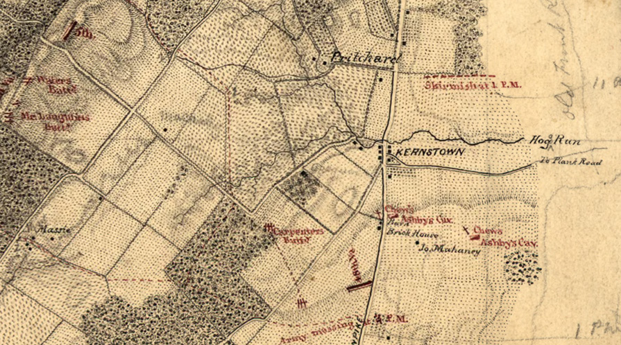
Highest quality; printed on heavy archival paper your choice glossy or matte:
Color Map 24x17.75 $55.00 The maps are printed from the original, therefore they're not perfect. Great effort has been taken to make them very suitable for wall display. The black and white prints can be rolled or folded for the field.
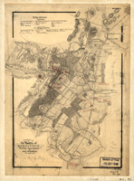
 1863 Civil War MAP; SECOND BATTLE OF WINCHESTER June 13th, 14th and 15th, 1863 to accompany report of General Ewell. By: Jed Hotchkiss, Top. Eng. 2nd corps
Highest quality; printed on heavy archival paper your choice glossy or matte:
Color Map 24x22 $55.00 The maps are printed from the original, therefore they're not perfect. Great effort has been taken to make them very suitable for wall display. The black and white prints can be rolled or folded for the field.
Last Updated June 1, 2012 Design and contact Jacque